
Team monitors ground movements during volcano eruption in Iceland
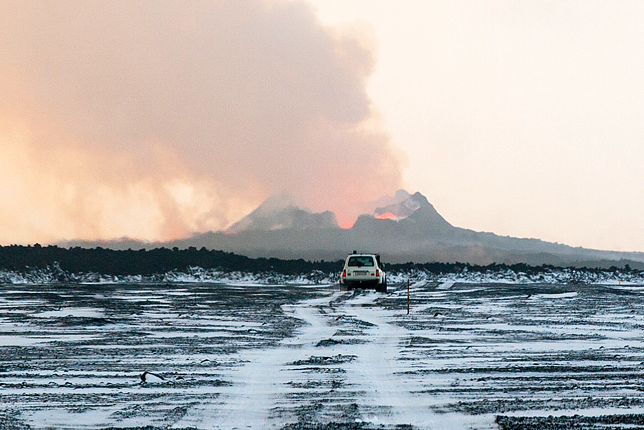
On the road to the eruption site. The main active crater in the background is part of a kilometer long eruptive fissure that feeds a 1km3 lava field, the largest lava volume emitted in Iceland for 230 years. Photo courtesy Dr. Joël Ruch
Associate Professor Sigurjón Jónsson, postdoctoral fellow Joël Ruch from the Earth Science and Engineering program of PSE Division, and collaborators from Italy and Iceland, recently visited the site of a large ongoing volcanic eruption in Iceland. The activity started on August 15 with an intense seismic swarm at the Bárðarbunga caldera (central Iceland), about 250 kilometers from the nation's capital of Reykjavík. Two weeks later magma reached the surface with a strong effusive eruption, which already represents one of the largest eruptions in recent decades.
By the end of August, a volcanic eruption started along a fissure located 45km from the caldera, emitting around 100-200 m3/s of magma. Researchers watched as seismic activity (being the expression of magma propagation into the surrounding rocks) moved towards the edge of the Europe's largest ice cap (Vatnajökull). The magma propagation pathway from the caldera, migrated laterally during the following two weeks to distances of over 45 km.
The Bárðarbunga caldera itself is covered by up to 800m of thick ice and is subject to strong deformation and seismic activity, along with a series of 60 earthquakes with magnitude above M5. A GPS instrument from the Icelandic Meteorological Office show the surface of the caldera is subsiding at the rate of about 0.5 meters a day, leading to an almost 50m deep depression at the glacier surface.
Created with flickr slideshow.
FIELDWORK CONDUCTED AT ERUPTION SITE
After a two-day trip from Iceland's capital Reykjavik, the team arrived at the eruption site on October 11. Access to the site is restricted, for safety reasons, and permissions are only granted to scientists, civil protection personnel and some journalists. The main goal of their study at the eruption site was to analyze and quantify the meter-scale ground movements related to a large new and evolving collapsed structure (called graben) that took place in response to the magma intrusion near the eruption site.
Ruch explains, "To retrieve accurate vertical ground displacements, we installed a profile of measurement points across the subsiding structure and measured the point locations with two GPS instruments. We plan to re-measure the profile hopefully early next year to obtain new information about further changes. The results will then be compared with displacement observations acquired from using satellite radar measurements of the same location. By studying the topographical changes before, during and after the eruption, we will be able to quantify volume changes and further integrate that data with the data obtained remotely and on the field.
The eruptive fissure is also emitting huge quantities of sulphur dioxide (roughly 40 kilotons a day) which is having a strong impact on the local population provoking frequent gas warnings. Researchers there are constantly monitoring the plume, depending on wind direction it can cause alerts in cities and towns, like Höfn and Reykjavik in an instant. As Prof. Jónsson explains, "It is causing huge pollution problems; the volcano is emitting four or five times as much sulphur as the entire daily industrial output of Europe. It is continuing to pollute to the extent that people are from time to time being told to stay in-doors and to avoid exercising outdoors. Iceland is known for its clean air which is not the case at the moment."
FROM ICELAND TO THE RED SEA
The fieldwork carried out by the team represents a rare case in which ground measurements and field observations have been undertaken during an ongoing magma intrusion (a dike) that is transiting below the surface, below the researchers very feet. Ruch explains, "Together with satellite radar data, it allows us to analyze how ground factures and faults develop and respond to magma intrusions. Such observations are important for analyzing and understanding how rift zones such as the one we have in the middle of the Red Sea, develop over time, and how oceanic crust is generated."
A single magma intrusion event like this has the power to generate permanent topographic changes, which usually take hundreds to thousands of years to develop. "This activity is comparable with what can occur at other divergent plate boundaries, such as in the Red Sea where two tectonic plates are moving apart from each other. It is also a unique case where you can actually walk where an oceanic crust is in the making, as 98 percent of these are usually submerged under water," Ruch said.
Plans are afoot for the team to visit the south part of the Red Sea early next year to study two new volcanic islands that were born in 2011 and 2013 in the Zubair archipelago. "It is something we are keen to study, because it is an emerged active rift zone affected by regular seismic swarms and magmatic intrusions that was previously under appreciated. Through our studies, we are aiming to highlight the Southern Red Sea magmatic activity as a major actor in the region."
Ruch and the team are under no illusions as to the importance of the recent trip. "We could get within 1 km of the eruptive fissure but no further as it is surrounded by the fresh lava field. The magma at the eruptive fissure can reach temperatures of up to 1,200 degrees, and as an active lava lake, is continuously flaring up."
In terms of what will happen next at the Bárðarbunga caldera, he adds, "We know the seismic activity is steady and there are no signs of decreasing activity. What we don't know is for how long or how it will develop over time."
At the time of writing this article, there was no signs of decreasing activity at the site.
- by David Murphy, KAUST News